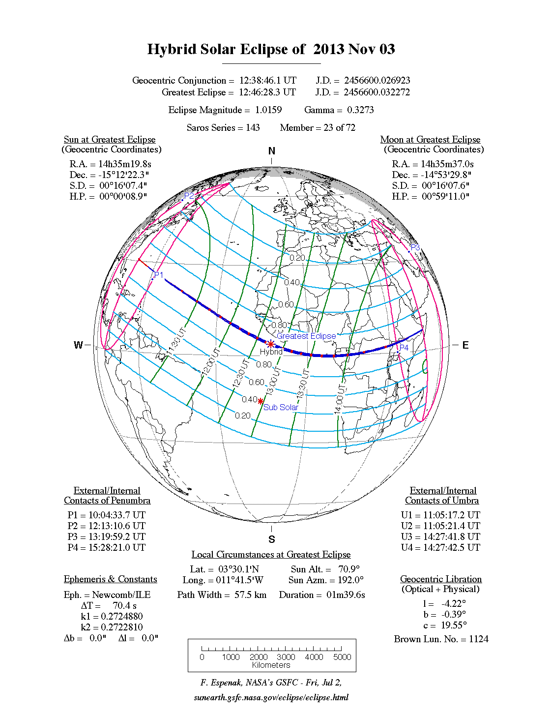
A hybrid eclipse of the Sun occurred on Sunday 3 November, 2013 UT, lasting from 10:04–15:28 UT. The Sun was darkened for 1 minute and 40 seconds by a dramatic hybrid eclipse covering a narrow path at most 58 km wide. This was a sight worth seeing, and was visible across the Atlantic starting east of Florida, and across central Africa. The partial eclipse was visible in northern South America, the extreme eastern US, and most of Africa.
The timings of the phases of the overall eclipse
worldwide are as follows. In any particular
place it would have been seen for a significantly shorter
duration as the shadow moved across the Earth:
| Partial eclipse began: |
10:04:34 UT |
| Central eclipse began: |
11:05:17 UT |
| Maximum eclipse: |
12:46:28 UT |
| Central eclipse ended: |
14:27:43 UT |
| Partial eclipse ended: |
15:28:21 UT |
During this eclipse the Sun was 0.537° in apparent
diameter, 0.8% larger than average. The Moon was just 3 days before perigee, making it relatively large.
At the start and end of the eclipse, the Moon was
0.537°, which is smaller than the Sun;
hence the eclipse was annular at that point.
However, at maximum eclipse the Moon was
0.546° in apparent diameter, which is
2.8% larger than average, large enough to cover the Sun; and so a
total eclipse was seen at that point. Thus
this was a hybrid eclipse.
The statistics page has information on the ranges of the sizes of
the Sun and Moon, and the Moon data page displays detailed
information on the Moon's key dates.
The central eclipse begain in the Atlantic south of Bermuda, soon becoming total. It then crossed the ocean and passed just south of Sao Tome and Principe before making landfall in Gabon. It then crossed Congo, DR Congo, Uganda, Kenya, and Ethiopia, finishing as an extremely short total eclipse in Somalia.
Interactive Map
This map shows the visibility of the eclipse. The area shaded blue
saw a total eclipse, and the areas shaded red saw an annular
eclipse; however, near the edges of each area, the eclipse was very
short. The bold line shows the centre of the path, where the eclipse
lasted longest.
Use the zoom controls to zoom in and out; hover your mouse over any
point on the centreline to see the time and
duration of the eclipse at that point. You can pan and zoom the map to
see detail for any part of the eclipse path.
The interactive map is currently not available.
Overview Map
This map sourced from NASA Goddard Space flight Center: GSFC Eclipse Web SiteGSFC Eclipse Web Site
The primary source of all the information on eclipses presented here at Hermit Eclipse. (NASA Goddard Space flight Center)
shows the visibility of the hybrid solar eclipse. It also shows the broader area in which a partial eclipse was seen. (Click on it for the
full-sized version.)
Eclipse Season and Saros Series
This eclipse season contains 2 eclipses:
This was the 23rd eclipse in solar Saros series 143.The surrounding eclipses in this Saros series are:
This Saros series, solar Saros series 143,
is linked to lunar Saros series 136. The
nearest partner eclipses in that series are:
Eclipse Parameters
| UT Date/time (max) | 12:46:28 on 3 Nov UT |
TDT Date/time (max) | 12:47:36 on 3 Nov TDT |
| Saros Series | 143 |
Number in Series | 23 |
| Penumbral Magnitiude | |
Central Magnitiude | 1.0159 |
| Gamma | 0.3272 |
Path Width (km) | 58 |
| Delta T | 1m08s |
Error | ± 0m02s (95%) |
| Penumbral Duration | |
Partial Duration | |
| Total Duration | 1m40s |
| |
| Partial Rating | |
Total Rating | |
| Sun Distance | 148393600 km (26.9%) |
Moon Distance | 370507 km (28.0%) |
| Sun Diameter | 0.537° |
Moon Diameter | 0.537° - 0.546° |
| Apogee | 14:25 on 25 Oct UT |
Perigee | 09:28 on 6 Nov UT |
| Contact p1 | 10:04:34 on 3 Nov UT |
Contact p2 | |
| Contact u1 | 11:05:17 on 3 Nov UT |
Contact u2 | 11:05:21 on 3 Nov UT |
| Max eclipse | 12:46:28 on 3 Nov UT |
| Contact u3 | 14:27:42 on 3 Nov UT |
Contact u4 | 14:27:43 on 3 Nov UT |
| Contact p3 | |
Contact p4 | 15:28:21 on 3 Nov UT |
Note that while all dates and times on this site (except
where noted) are in UT, which is within a second of civil time,
the dates and times shown in NASA's eclipse listingsGSFC Eclipse Web Site
The primary source of all the information on eclipses presented here at Hermit Eclipse. (NASA Goddard Space flight Center)
are in the TDT timescale.
The Sun and Moon distances are shown in km, and as a
percentage of their minimum - maximum distances; hence 0%
is the closest possible (Earth's perihelion, or the
Moon's closest possible perigee) and 100% is
the farthest (aphelion, the farthest apogee).
The statistics page has information on the ranges of sizes
of the Sun and Moon, and the Moon data page displays detailed
information on the Moon's key dates.
Data last updated: 2015-06-21 22:11:46 UTC.